Well, today we hiked the Piccos Ridge Trail from Portugal Cove to Bauline. They say that the best views in the world are the ones you work for, and if that is true, this must be the most beautiful place on earth! We recently read someone's Facebook post, which claimed this stretch of trail was the hardest hike they'd every done, and I think we ended the day in full agreement!
To backtrack a little, we innocently began our day with a breakfast of coffee and bagels in MUN. As we ate we admitted to being a little nervous about today's trek, partially because of the weather advisory, which still called for temperatures to drop to -1 by the evening, 1-3 mm of rain throughout the day with an additional 10-40 mm projected overnight (or snow!), and high winds, and partially because of the description of the trail itself. In short our first day on the ECT and Trans Canada Trail was nothing like we expected - especially in June!
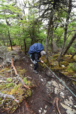
According to the East Coast Trail Association, Picco's Ridge Path is a 14.5 km footpath which runs from Portugal Cove to Bauline along Picco's Ridge. The trail is described as a tough trek over a rugged landscape, and hikers are advised that they should be prepared for several rope-assisted ascents and descents. We were warned of steep ascents/descents at Black Cliff, Picco's Ridge, and Brock's Head, but encouraged by the promise of stunning views up and down the coast and out to Bell Island.
With these thoughts in mind we checked out of our residence room, and the helpful staff at the reception desk phoned a cab (Newfound Cabs) to take us to the Bell Island Ferry terminal in Portugal Cove. We had been advised that this was the best course of action because few taxi drivers seem aware of the trailhead in Portugal Cove, and many are reluctant to simply leave hikers at the edge of the road. It seemed this was good advice, because even though we mentioned what we were doing to the very friendly driver of the cab, he spent the trip describing his family's trips to Bell Island, noting how nice everyone was there and how many great places there were to go and see on the island. Given his enthusiasm we didn't have the heart to correct him regarding our destination. It was a $35 ride, and as we were dropped off, the ferry was just pulling in.

Once out of the cab and near the ferry terminal we were soon conversing with another friendly man who also extolled the virtues of the island, describing a mine that could be visited, the new ferry they put in, and several hiking trails, and showing us an incredible photo he had taken of Fort Amherst. He almost had us convinced to give it a try.
As a side note, today was Discovery Day, or John Cabot 500 Day in Newfoundland, which is a holiday celebrating the discovery of the island that always falls on the nearest Monday to June 24th. So, in honour of Discovery Day, we began discovering what the East Coast Trail has to offer.
So, from the ferry terminal we headed up the road, found Loop Drive, and with the help of a very kind man out walking his dog, found North Point Road, which we followed around to the trail head.
Although we felt briefly that we were lost, we remembered the directions we found on Randy Best's website, which have been extremely useful. In some ways there are frustratingly few resources available from either the East Coast Trail Association or the Great Trail (formerly Trans Canada Trail) regarding this section of the trail, or even the more developed ones farther along the coast. The exception is Randy Best's website (https://www.ectthruhike.com/), which includes detailed spreadsheets showing potential campsites, available water sources, distances between everything, and narrated YouTube walks of each trail. All of these resources have been truly invaluable in planning our hike, and we would like to send out a huge thank you to him for putting all that information together!
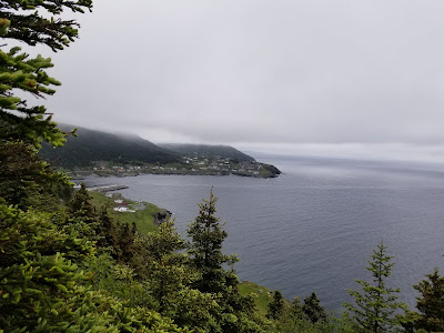
From the trailhead the path followed the coast through a flat grassy area for a short distance, and then began a steep climb along a series of very well constructed sets of stairs. The climb couldn't have been made much easier for us, and we were very grateful to the trail captains and ECT volunteers for their work here. This section gave stunning views of Bell Island and back over Portugal Cove.
After the climb we found ourselves following a small footpath through a dense coniferous forest of spruce and fir. The ground was carpeted in thick green moss, and the many small balsam firs made the air smell like Christmas.
After this for most of the day we were treated to a variety of different experiences, ranging from quite a bit of picking our way along very muddy and wet sections of trail in marshy areas, to climbing very steep and exposed sections of rock, to traversing exposed areas with views of ponds and lakes below us, to threading our way through stands of dead trees.
At one point we found ourselves hiking down a waterfall - water and all. I'm not sure if it is always this wet, but today it certainly was! Can you see the trail?
As the day progressed, the fog started to roll in and out, making Bell Island appear at times to be 3D and highly defined, while at others is looked like it was receding into the distance, and at still others it was completely invisible.
The middle section of the trail was in parts difficult to follow and navigate, especially where conifers had begun to grow across the path. It was hard to push through them with our large packs, and we were soon soaked from doing so. In addition, much of it was marked in flagging tape, and there were a few side trails where it wasn't too clear which set of flagging tape we were meant to follow. We didn't get lost though, so all was well.
After 4 hours of hiking we met a
young lady with a full backpack struggling to return
to Portugal Cove. Apparently she had started out yesterday to thru
hike in the same direction as us, got caught in the rainstorm on the way, her pack and all of
her supplies got drenched, and she spent the night on the trail side
hoping to avoid hypothermia. She was shaking, alone, and clearly unnerved, and asked if we had heard about the severe weather warning. We said yes, and asked what was coming up ahead, and she warned us that if the weather turned and we saw a spot to stop we should take it, because the options were few and far between, but she thought we could make it to Bauline. While I'm sure it was not her intention, this meeting kind of unnerved us as the day progressed and the weather started to deteriorate.
Shortly after we met her we thought we heard a bark or a scream behind us, and, worried that this hiker had suffered an injury, we stopped and turned around, only to see two hikers on the ridge behind us pointing at a beautiful black fox with a white tail tip running across the trail with her cubs. That was super cool to see! Other exciting wildlife sittings included a pair of Pine Grosbeaks and a Bald Eagle soaring below us over the Atlantic. Throughout the day we were serenaded by the whispery calls of Dark-eyed Juncos and the loud clear songs of White-throated Sparrows.
An hour or so later we met another
two young ladies day hiking the section who also warned us to avoid
being on the trail with the coming bad weather – advice that was
most welcome. However, given that by our
estimations we had covered about half of our desired distance, we
felt safe in continuing onward. Several hours later we began to
question the wisdom of this choice. The weather alternated between
dense fog, strong winds, cold breezes, warm sunshine, and rainy
drizzle. Around this time our Garmin device suggested that despite walking continuously for several hours, we hadn't really gotten any closer to Bauline. This information did little to improve our attitude or rising concern regarding the situation.
By around 2 pm we got to the sign for Piccos Ridge, which is only about 3 km from Bauline, and our spirits perked up. As it turned out, there was very little reason to celebrate. An hour and half later we were still struggling along a path that was precariously steep, and which included a
series of brutal rope-assisted descents and ascents as promised – with nerve-wracking drop
offs nearby.
For example, if you zoom in on the photo below you can see the light line of the path on the side of the hill ....
As it started to rain and the wind picked up the steepness of the ridge and our extreme proximity to the edge almost persuaded us to turn back or set up camp early
on Piccos Ridge. However, with no place to stop on the steep slope, we had little choice but to continue onward as the temperature started to drop.
By 4 pm, after 7 hours of hiking,
we stumbled into the seaside village of Bauline. It was at this time that it truly started to pour (as well as slush), and we wanted to set up as quickly as possible. After quickly scouting around, we decided to pitch our tent in what we hoped would be the shelter of two boats that were drawn up in the picnic area at the edge of town.
Together, amid 50-60 kph winds
and pouring rain, we set up our tent and got our tarp pegged down.
Once our basecamp was up we both jumped into the tent, hauled our
backpacks apart and began changing into dry clothes. As the evening set in our tent was
continually pummelled with the full force of the winds off the Atlantic
Ocean that were apparently gusting to 80 kph, and drenched by a heavy rain storm.
We huddled amid the fierce winds
of Bauline until almost 8 pm, thanking the gods we were dry and warm, and
reading about tomorrow's hike and checking on the expected
weather. By 8:30, with no great news
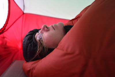
forthcoming, I changed back into my wet cloths and braved the storm outside the tent to filter water and cook supper, which consisted of reconstituted Mountain House vegetable lasagna. When the warm meal was done, we were snuggled into our winter sleeping bags, thanking heaven to be warm and dry in the midst of the storm. Here I need to thank all of those who advised us on the facebook group "Hiking in Newfoundland" that it was best to take winter sleeping bags and clothing for evenings!
We are now left with the question of whether to proceed along the next trail
section tomorrow, which is described as being even more difficult than Piccos Ridge, whether the get a ride to the nearby Marine Park to wait out the bad weather there, or whether to go back to St. John's to dry everything out and continue on once the worst of the wind and rain are past. As I watch the tent flap and quake in the wind I am inclined to think that braving a muddy, washed out trail in this wind would be nothing but foolhardy and dangerous. We will see what tomorrow brings.
_____________________________________________________________________________
Practical Information:
Paths: Piccos Ridge
Distance Hiked: Trail =14.5 km
Max Temp: 7.4 °C
Min Temp: 3.6 °C


Great adventure, ending in a cliff hanger! (pardon the pun.)
ReplyDeleteLove it Sonya & Sean!