East Coast Trail to Cape Spear : Blackhead to Maddox Cove - Petty Harbour
East Coast Trail to Cape Spear
Blackhead Path
We were up at 6 AM this morning. As we made our breakfast of oatmeal, raisin bread and coffee we watched as a huge fog bank rolled in off the ocean, completely obscuring St. John's harbour. The fog was so dense we assumed that our views from Cape Spear would consist only of the immediate coastline, but to our amazement, half an hour later the fog had burned off, leaving only blue skies. The weather on the edge of the Atlantic really is fickle.
After packing everything up we set off along the very short community connector to the Blackhead Path trailhead on the other side of town. The Blackhead Path, which is fairly short, began with a steep climb up a rocky slope.
Birdwatching along the East Coast Trail
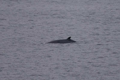
As we paused to catch our breath, we looked back over the harbour and to our great delight saw a minke whale!! He surfaced a few times before disappearing. As we watched we noticed a group of Northern Gannets circling above the whale, as well as a couple Great Black-backed Gulls cruising nearby. Looking down we suddenly noticed a Bald Eagle perched atop a rock outcropping, calmly watching the whole spectacle. It was a morning of natural wonders!
After a somewhat precarious climb along the coast, we came to the foundations of two dummy forts which were
built during the Second World War as a means of convincing enemy
aircraft and naval vessels that the Newfoundland coastline was
heavily defended. This is one of the unique features of the East Coast Trail that we are thoroughly enjoying - it is so rich in both nature and history, and it offers so many unexpected delights every day.
Cape Spear
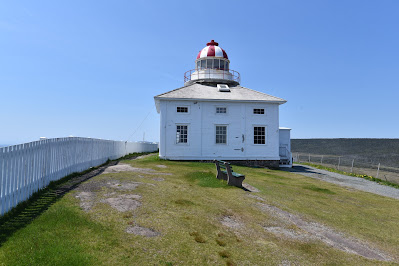
About an hour later, after hiking along the coastline and enjoying clear views back to Fort Amherst and Signal Hill, we arrived at the Cape Spear National Historical Site.
Cape Spear is the easternmost point on mainland North America and is the site of a lighthouse with a unique octagonal tower. It was also used as a long-distance defender of St. John's Harbour during WWII and has a battery to serve that purpose. Although the lighthouse was closed for renovations when we visited, luckily the gift shop was open, and we ended up enjoying a warm coffee and some local Newfoundland chocolate while we watched tour buses load and unload. It was a gorgeous sunny day, and many people were out enjoying it.
Cape Spear is the easternmost point on mainland North America and is the site of a lighthouse with a unique octagonal tower. It was also used as a long-distance defender of St. John's Harbour during WWII and has a battery to serve that purpose. Although the lighthouse was closed for renovations when we visited, luckily the gift shop was open, and we ended up enjoying a warm coffee and some local Newfoundland chocolate while we watched tour buses load and unload. It was a gorgeous sunny day, and many people were out enjoying it.
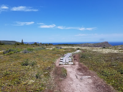
As we continued along the Cape Spear Path, which began behind the lighthouse, we headed off in the direction of North Head, a spit of land that we reached about an hour later, having traversed a relatively flat section of trail with many boardwalks. In this open grassy landscape, dotted with boulders, our pace picked up a little.
After rounding North Head we joined several other hikers who were sitting on the side of the trail near a picaresque waterfall, watching the waves. One gentleman spotted a humpback whale, but we weren't fortunate enough to catch a glimpse.
Along this stretch the trail continued lazily along the shoreline, providing majestic views with little effort on our part, although at one point we encountered clouds of swarming insects. Perhaps the most striking feature of this area was the large glacial erratic which were cast across the landscape. Each clearly had its own story, and added such a presence to the region that I wish we knew more about the geology of the area. Regardless, they were beautiful and fascinating.
The last three hours on the Cape Spear
Path we spent leap-frogging a group of ladies on a local tour –
each was very happy and loved the great weather and sites and the
challenges the trail presented. They were also from Toronto, and at one point they filmed me as I attempted to cross a particularly difficult stream. If I had fallen in I likely would have become an Internet meme, but luckily that situation was avoided!Along this stretch the trail continued lazily along the shoreline, providing majestic views with little effort on our part, although at one point we encountered clouds of swarming insects. Perhaps the most striking feature of this area was the large glacial erratic which were cast across the landscape. Each clearly had its own story, and added such a presence to the region that I wish we knew more about the geology of the area. Regardless, they were beautiful and fascinating.
The final 2 km of the rail into Maddox Cove - Petty Harbour seemed more challenging than this morning's hike, and they included descending a cliff in the middle of a rushing waterfall. It was a little scary, but rather exhilarating at the same time!
By late afternoon we found ourselves at the edge of Maddox Cove - Petty Harbour. The town of Petty Harbour is a traditional fishing village which is known as a popular filming location for various movies, including one of my favourites - Rare Bird. We paused at the picnic tables at the edge of town to have some water and then headed into town in search of some dinner.
Although a number of options were listed in our guidebook as being available, we found only Chafe's Landing Restaurant to be open. This turned out to be an excellent place! I had a very tasty veggie burger and fries, while Sean had a bacon cheeseburger. As we ate we enjoyed live music coming down from upstairs!
Feeling refreshed from our dinner we decided to continue on to the Motion Path to find a campsite that was listed as being about 5 km in. The path began with a very steep climb out of town, but then it levelled off along the clifftops, which were covered in fields of heather, heath,
spring flowers and the skeletons of a long dead forest. In the fading light, it was a very beautiful sight!
We passed Freshwater River, which is where we thought we would find the campsite, but there was no shelter, and no flat areas to pitch a tent, so we continued on. When we reached a spot about 3.5 km past Petty Harbour we found a single mossy, flat-ish spot sheltered by trees on which to pitch our tent. It is extremely soggy and hosted an inordinate number of blackflies, but for tonight it is home.
By 6 PM we had pitched the tent, gone back to Freshwater to fetch some water, and done some laundry. Now, as we perch atop a rock looking out over the Atlantic and watching a harbour seal float below us, we feel that today has been our best day on the ECT and Trans Canada Trail so far - it gave us whales, gulls, eagles, Cape Spear and almost 18 km of trail covered!
See you on the Trail!
_____________________________________________________________________________Practical Information:
Paths: Blackhead Path, Cape Spear Path, Motion Path
Distance Hiked: Trail=18.7 km, Connectors: 2.8 km, Total = 21.5 km
Max Temp: 24.2 °C
Min Temp: 7.5 °C 


Comments
Post a Comment