Tinkers Point and Beaches Path ECT : Witless Bay to La Manche Provincial Park
Tinkers Point and Beaches Path ECT
East Coast Trail Hike
We awoke early and enjoyed another
wonderful breakfast, this time in the company of two other couples
staying at the Inn. This morning's repast was prepared by the owner
and operator of the inn, whom it was nice to finally meet.
After
checking out we set out on the roads of Witless Bay. This is a very
long town connector between trailheads, but it was generally well-marked by individuals along the way. As we headed to the Beaches Path trailhead, a young man pulled up in his car and offered us a
card for the Whale House, suggesting that if we wanted lodgings or a
cup of coffee in Mobile we should look them up. Although we
will not be stopping in Mobile, it seems we may have missed a good
opportunity by not staying at this establishment.
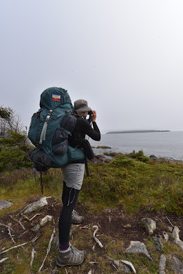
The Beaches Path was different than anything we have encountered along the East Coast Trail so far. It was a short 7 km trail, which took us along the coast near water level for a change. We walked across boulder beaches, through meadows along the shore, and along treed footpaths next to the water. In several sections, there were boardwalks over muddy or wet areas, although a few of these needed some repairs. Many of the broken sections had been marked with flagging tape, so maybe some TLC will be provided in the near future. Generally, this trail was well developed and an easy and enjoyable walk.
As we progressed along the path, we could see Gull Island and the swarms of birds flying above it. This was very entertaining, as were the many Atlantic Puffins we could see floating offshore. It was amazing to see how differently these birds land on the ocean, compared to the graceful movements of ducks and geese landing on ponds. Maybe it is the rough waves, but it often looks like puffins do a kind of face plant in the water when they land. They are equally endearing when they come up from a dive, seeming to emerge backwards, with wings and feet flailing. So cute!
Towards the end of the Beaches Path, as
we were crossing an area of dense firs and spruce, we were surprised
when a beautiful Ruffed Grouse jumped out onto the trail, warbled at
us, and then took off. We sat for several moments and it soon
returned. It must have had either a nest or babies on the trail
side, and not wanting to disturb it too much we soon walked on. Not
however before watching a pair of Northern Waterthrush carrying food
to their nestlings in the same area.
As the day progressed it became warmer,
causing us to remove our sweaters and leggings. As we emerged from the trail into
the village of Mobile we were met with the somewhat unwelcoming sight
of dozens of “Private Property”, “Stay on Trail”, “Hikers
Respect Property Rights”, etc. signs around the trailhead. Once
past the residential section of this village, we arrived on a pleasant
boulder beach where we enjoyed some water and a snack and watched a
pair of Greater Yellowlegs foraging along the shore.
Tinkers Point Path
After a short break, we made our way
uphill along Cove Road to the Tinkers Point Path trailhead. This
trail turned out to be similar to the Beaches Path, and we were again
treated to views of Puffins and Razorbill birds offshore. This path
was also not as challenging as the ones we have traversed so far, and it
was quite enjoyable to be able to look around more without
immediately tripping over a rock or a root.
The Tinkers Point path eventually
brought us to Tors Cove, past a place called “The Cribbies,” which is a very beautiful little settlement. Everything about this small area
was picturesque. Soon afterwards the trail rounded the hillside and
entered Tors Cove above a large abandoned factory, next to a
beautiful but derelict church.
With a single sign at the trailhead indicating which road to take, we began our walk through Tors … and promptly got lost. Upon inspection, we learned that the ECT map suggests “once you leave the Tinkers Path walk 600 m to the next trailhead.” This was not the most useful advice to one unfamiliar with the area. Guesswork led us to the harbour, up to the powerhouse, and onto a well-used gravel road. During our time on this road, we had to remain vigilant as both motorbikes and ATVs used this route at high speed and with little inclination to slow down or stop for hikers.
With a single sign at the trailhead indicating which road to take, we began our walk through Tors … and promptly got lost. Upon inspection, we learned that the ECT map suggests “once you leave the Tinkers Path walk 600 m to the next trailhead.” This was not the most useful advice to one unfamiliar with the area. Guesswork led us to the harbour, up to the powerhouse, and onto a well-used gravel road. During our time on this road, we had to remain vigilant as both motorbikes and ATVs used this route at high speed and with little inclination to slow down or stop for hikers.
Having survived the gravel track, we
soon found ourselves on a paved road that took us through the
villages of Burnt Cove, St. Michaels, and Bauline East.
Given the heat of the day, we were grateful to find the Ocean View Bakery in Burnt Cove. The delicious smells coming from within prompted us to buy 6 oatmeal cookies, 6 chocolate chip cookies, and two cold drinks. These we enjoyed on the back deck of the bakery, which afforded a fantastic view of Fox Island, Ship Island and Pee Pee Island. Twenty minutes later, relaxed, re-energized, and having eaten too many cookies, we went back inside and purchased a cake for our evening dessert before continuing on.
Given the heat of the day, we were grateful to find the Ocean View Bakery in Burnt Cove. The delicious smells coming from within prompted us to buy 6 oatmeal cookies, 6 chocolate chip cookies, and two cold drinks. These we enjoyed on the back deck of the bakery, which afforded a fantastic view of Fox Island, Ship Island and Pee Pee Island. Twenty minutes later, relaxed, re-energized, and having eaten too many cookies, we went back inside and purchased a cake for our evening dessert before continuing on.
We walked through St. Michaels, past Seals Cove, and alongside Bauline Pond, which reminded us of Northern Ontario, to Bauline East. Uncertain how to proceed, we rested at the Bauline pier, had some water, checked our maps, and fought off the blackflies. We were soon pointed in the correct direction (straight uphill) by two lovely ladies who were walking their dogs.
La Manche Provincial Park
After a steep climb, we entered back
onto a grassy track, bordered by trees. As we neared the La Manche
Provincial Park boundary we met a young lady coming down the track
who recognized us from Facebook. Small world! She offered us
encouraging advice and told us that we were almost to the main part
of La Manche Provincial Park.
As we trekked along the pathway it was
clear that parts of it were an access road and that lots were being
prepared for housing and development – I can only hope that the
natural integrity of the region is also being preserved as the area
builds up. As we entered the park, the changes in the trail were
evident. Suddenly we found ourselves walking along a well-developed,
flattened, poured gravel path. A great deal of this section of
pathway is also on exposed rock face – much like the shield in
Northern Ontario. Soon we arrived at Doctor's Cove – the first of
our potential stopping points for the day. However, it was only 3
pm, there were countless groups of teenagers on the beach, making it
a rather busy place, and so we decided to continue on.
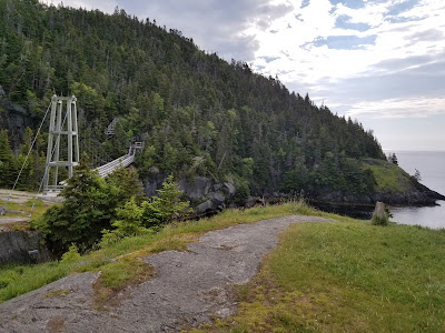
Shortly after this point, the path led to a boardwalk which clung to the side of the rock face. After turning the corner the noted La Manche Suspension bridge came into view! Before reaching the bridge we climbed a long wood staircase up a hill, just to turn back down again, but it did give wonderful views of the bridge. The 45-foot-long suspension bridge spans a chasm over a beautiful waterfall. On the other side of the bridge, we found the trailhead for the La Manche Village Path, marking the completion of this trail and the point where we will return tomorrow.
Still feeling energetic and in good
spirits we decided to walk into the Provincial Park to get a campsite
there, and hopefully enjoy a shower. With this in mind, we headed up
a path leading away from the bridge, which was frequented by many
other hikers. We soon found a pond full of green frogs – the first
sign of frogs we have seen on the trail so far! We thought we were
walking toward the campsite, but instead,d we ended up climbing Hell
Hill. When the trail finally ended in a parking lot we called the park
office to ask where we were and how to reach the campsite. A very
helpful park attendant ably directed us down the fire route straight
into the campsite. It was through his helpfulness that we were able to
get to the office, check-in, and get set up for the night in a very
nice campsite close to the entrance, so we didn't have much farther
to hike.
That evening we were able to have a campfire, enjoy a shower in the wonderfully clean comfort station, and do some laundry. We also got to chat with another gentleman who was a tour operator going out to the Ecological Reserve, and a photographer. For dinner, we cooked up a meal of rice, vegetables, wraps, and cheese, which we ate beside our campfire. It was a nice ending to a wonderful day.
Tomorrow we are uncertain how far we
will get along the Great Trail / Trans Canada Trail – the next section of the trail is listed as difficult so
our goal is approximately 8 km out of the park to the ECTA established campsite at
Roaring Cove.
See you on the Trail!
Practical Information:
Paths: Beaches Path, Tinkers Point Path, La Manche Village Path
Distance Hiked: Trail = 19.3, Connectors: 7.4 km, Total = 26.7 km
Max Temp: 24.0 °C
Min Temp: 8.8 °C


Comments
Post a Comment