Mudder Wet Path East Coast Trail : Ferryland to Chance Bay
Mudder Wet Path East Coast Trail
ECT Thru-Hike
It felt good to be heading back onto
the East Coast Trail this morning, and we were up early to pack and get ready.
After much debate, and online chats with other hikers about their
recent experiences on the Sounding Hills Path, we decided to hike
Highway 10 to Aquaforte and continue south on the Mudder Wet Path
from there. It was crummy to lose a section of both the ECT and Trans Canada Trail / Great Trail, but we felt it
was best to respect the wishes of the local authorities until the
situation could be resolved. We would like to thank those online, on
Twitter, on Facebook, and on email who advised us regarding this
section. We would also
like to thank all those volunteers and landowners out there who help
support the ongoing operation of their local trails, and who allow
hikers to pass through their properties – the system only works
because of your generosity, so a huge thank you!
With another amazing breakfast under
our belts we paid our tab, said our goodbyes, and set off on the 5 km
road walk to and through Aquaforte. This turned out to be a largely
uneventful trek, with motorists kindly slowing down as they passed
by, and a few stopping to offer us lifts. It took us about an hour
to reach the community of Aquaforte, which is another small community
whose history and current economy are tied closely to the fishing
industry. Today a seafood processing facility is the major employer
for residents from this and surrounding communities, and we passed it
on our way by.


We made it through Aquaforte and soon found the trailhead for the Mudder Wet Path. The beginning of the path took us through a small wetland, where Pitcher Plants and other wildflowers were in full bloom. It was quite a beautiful wetland, complete with boardwalks to take us over the wetter portions.
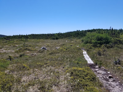

After the meadow the trail took us down to the coast, where we found that the tide was out, letting us cross the cove before climbing steeply back up onto the ridge and resuming our progress northward.


After that, it was a relatively easy and pleasant hike along the coast, with a few gentle ascents and descents.


Spurwink Island Path
The Spurwink Island Path met the Mudder
Wet Path in a patch of bush near Highway 10, and just after the join
we crossed a bridge over an impressive waterfall. From there the
Spurwink Trail delved into some long stretches of scratchy brush and
waste-high shrubbery, making parts of the trail difficult to see.
Mostly the beginning of the trail wasn't too difficult, although it
was mostly inland and didn't provide too many views of the ocean.

At one point we spotted a seal in a nearby cove, who continually popped up out of the water and seemed to pose for us. After that, the trail became somewhat more difficult, with stretches of crumbling and rotting infrastructure, mud, and boulder scrambling becoming more frequent occurrences.

At one point we spotted a seal in a nearby cove, who continually popped up out of the water and seemed to pose for us. After that, the trail became somewhat more difficult, with stretches of crumbling and rotting infrastructure, mud, and boulder scrambling becoming more frequent occurrences.
As we progressed we came to Spurwink Island, which was a beautiful and colourful rocky island jutting up out of the blue ocean below, and we once again had a clear view of the Ferryland lighthouse and the peninsula it sits on.


We reached the Gallows Cove Campsite around 2 pm, still feeling somewhat energetic. It was a beautiful spot to camp, but since it was still early we decided to push on a bit farther, making Chance Bay our final goal for the day. We soon reached South Head, which provided great views of Spurwink Island, the Colony of Avalon, and the Ferryland Lighthouse.

Berry Head Sea Arch
After that, it seemed like a short hike
to the popular Berry Head Sea Arch, which seems to be considered one
of the highlights of the ECT. At this spot erosion and and wave
action have worn away the coast to form a magnificent 'bridge.'


After this point, the trail became
increasingly muddy and difficult to navigate, and we were starting to
get a bit tired.


Chance Bay Campsite
As the trail passed into a dark tunnel of conifers
and began to climb we started to wonder if we had somehow managed to
miss Chance Bay. Luckily, as we emerged from the tunnel we started
to hear the sounds of a roaring waterfall, and we soon reached Chance
River. There we found a wonderful grassy spot to pitch the tent,
thanks to the advice and directions provided by Randy Best –
without his guidance, we probably would have passed by the spot
without noticing it.

We made a dinner of pasta, wraps, and cheese and watched the sunset over the cove, which was occupied by several Herring Gulls, a Northern Gannet, and two seals. We also saw a couple of whale spouts out to sea!


As we settled into our tent for
the evening, it felt like a good day. It was a long walk, but not so
challenging that we didn't enjoy it, and we have discovered that if
all goes well, we could finish the trail in only two days.

Tomorrow our goal will be the Bear Cove
Point lighthouse.
See you on the Trail!
______________________________________________________________________________Practical Information:
Paths: Mudder Wet Path
Distance Hiked: Trail = 12.6 km, Connector = 5.5 km, Total = 18.1 km
Max Temp: 22.2 °C
Min Temp: 10.6 °C
Comments
Post a Comment