End of the East Coast Trail : Bear Cove to Cappahayden
End of the East Coast Trail
Blackflies and Trailheads on the ECT
This morning dawned sunny and warm, and
we were up and ready to head out early on the East Coast Trail. As we emerged from the woods
at the lighthouse, a few hundred meters from where we camped, we met
a small group of determined individuals conferring around a pile of
construction materials. It turns out they were the work crews doing
maintenance on the trails! We thanked them profusely for their
efforts and continued on our way along the Trans Canada Trail / Great Trail sections being upgraded.
Sadly, it turned out that the work crews started at the lighthouse and were working their way northward, so we were soon back to threading our way through mud and rock scrambling. However, the trail wasn't too bad, and it was a nice morning, so we ended up being able to enjoy ourselves and maintain a fairly good pace until we reached Renews.
Renews Newfoundland
As we approached Renews the trail entered a grassy area, which was again crisscrossed by ATV trails and tracks. After looking at the map we decided that if we stuck to the water, and followed the road around the harbour we'd be fine. A few minutes later we had lost the trail.
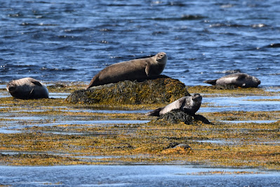
A little farther along the road, we noticed a group of seals basking on the rocks in the harbour. They looked very lazy and endearing.
We continued around the picturesque harbour, having to backtrack a couple times until we found Highway 10 and the crossing. When we crossed the bridge at the back of the harbour, we found a sign indicating the area was well-known for trout fishing. We also came to a high-end rest area, complete with several picnic tables and a bank of informative signs about the geography, history, and nature of the area. Apparently, the harbour and river mouth is a well-known birding area, featuring American-golden Plovers, Whimbrel, Ruddy Turnstone, Spotted Sandpiper, Black-bellied Plover, Semipalmated Plover, and Greater Yellowlegs. As we took a break we watched several Greater Yellowlegs foraging in the mud flats, a Belted-kingfisher fly past, many Common Terns fishing in the bay, as well as nesting on an offshore island, and an Arctic Tern flying around in the mix.
Having spent an hour at the coastline admiring the shorebirds we continued along the southern shore of Renews harbour and soon met John, who invited us into his amazing shop, the Merrymeeting Place, to relax without our packs and enjoy a coffee with him. His shop was filled with beautiful paintings and crafts, many of which were produced by John and his wife, as well as other local artists. Had we not been hiking, and limited in what we could carry I know there were a few beautiful paintings that we would have loved to take home with us, but as it was we settled for a couple handmade cards. It seems that John is another trail angel for hikers, offering his assistance to those in need. He talked about growing up at the Bear Cove lighthouse where we camped, and about being involved with the ECT, and doing beached bird surveys over miles of beaches on the Avalon Peninsula. It was wonderful to chat, but eventually, we had to head out, as we had already arranged for a taxi to pick us up in Cappahayden in the evening.
As we continued down the road, a very
nice lady asked us if we needed water or a break – we thanked her,
but given that we had just taken a break we continued on. We left
feeling heartened by the hospitality of Renews, which was rare and
beautiful.
We soon found the Island Meadow trailhead at the end of yet another gravel track and began the final
section of the East Coast Trail. The trail began as a gentle track,
and for the most part, followed the coast.
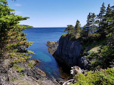
There were some lovely views of the coast, and at one point we stopped to watch a couple of seals in a cove down below.
We had been excited to read in the description of the trail that there were no major ascents or descents, so when we discovered the steep, muddy, and rocky climb in the middle of the trail we were less than enthusiastic. When we found the sign designating it as Gripes Nest Hill at the top, that was a pretty accurate description of what we were doing at that point! The trek back down the other side was nearly as challenging as the climb up - which contributed to our own griping.
As the afternoon progressed we noticed that the fog bank which had been hovering just off the coast all day seemed to be coming inland, so we picked up our pace. I think we may also have been going at a faster-than-usual pace in an attempt to outrun the swarm of black flies, but they seemed to only increase in number and ferocity the farther south we went.
Island Meadow Path
About halfway along the Island Meadow Path, we took the opportunity to take a break on Bear Cove Beach, which sits alongside Highway 10. Even on the pebble beach, there were a lot of black-flies, so after a short rest, we continued on, behind several large houses, and into a dense forest.
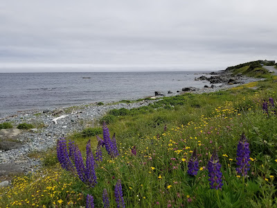
We continued along the coast for a while, past a farm with horses, and then onto a final spit of land which was covered in a meadow of heath that was dry and mud-free!
After this, it was a short walk along the coast, past a horse corral, and into the village of Cappahayden.
End of the East Coast Trail
We passed a monument to a sunken ship and then found the sign which marked the end of Island Meadow Path,
and the sign right beside it that marked the end of the East Coast
Trail. Wow. It felt kind of strange to be done, and in some ways a
little anticlimactic. There was no giant cathedral, or crowds of
people to share our accomplishment with, but there was a quiet kind
of satisfaction that we had made it.
As we sat in the meadow, getting eaten
by black flies and waiting for the taxi to pick us up, the fog finally
rolled in and swallowed up the land. It was one of those strange
moments that we have encountered so frequently on the trail – where
there seems to be a 10-degree shift in temperature from one moment to
the next. Not unpleasant exactly, but rather disconcerting. It felt
like the weather had held off just long enough for us to finish the
trail – we began with snow, and we ended with an approaching
tropical storm advisory,
but everything in between had worked out wonderfully well.
Return to St. John's Newfoundland
The taxi ride back to St. John's, where
we decided to stay at Memorial University again took about an hour. It was a strange
feeling to see all the places we had hiked through flash past again,
like a kind of mini-review. The taxi driver was another friendly
local, full of stories about the island, the region, and his life.
Since it was rather late when we arrived back at MUN we quickly
showered and headed back out to find some dinner. We ended up at a
lovely Mexican restaurant called Quintanas, where we split a plate of
nachos, had a celebratory pint of Quidi Vidi beer, and shared a
wonderful dessert consisting of fried pastry topped with warm honey
and cinnamon.
By 11 pm we were back in our room,
warm, dry, clean, well-fed, and ready for bed. The rains hadn't
started yet, but we were glad to have been able to finish the trail
safely, and grateful for all the wonderful things we saw and
experienced, and the wonderful people we met along the way.
See you on the Trail!
______________________________________________________________________________Practical Information:
Paths: Bear Cove Point Path, Island Meadow Path
Distance Hiked: Trail = 15.6 km, Connector = 5.1 km, Total = 20.7 km
Max Temp: 26.8 °C
Min Temp: 15.1 °C


Comments
Post a Comment